Why El Niño matters even for your 5‑day forecast
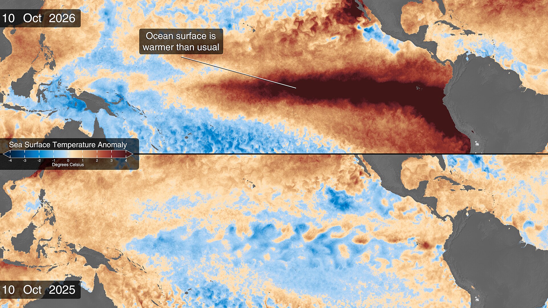
Several recent reports reviewed by Freedom News Staff indicate the developing El Niño is not only a seasonal concern but is already showing up in short‑range forecasts. Yahoo’s coverage cited the latest NOAA/Climate Prediction Center advisory and model guidance, including operational model suites often referenced by forecasters such as CFSv2 and ECMWF, and concluded the evolving Pacific pattern is nudging storm tracks and the jet stream in ways that can alter five‑day outlooks in specific regions.
That linkage is not a new idea: large tropical Pacific temperature anomalies change the atmosphere’s large‑scale circulation, and those changes can bias where storms are most likely to travel. The recent cluster of reporting — from national outlets to local papers in California and the Pacific Northwest — suggests forecasters are watching model runs more closely for signs that incoming Pacific systems will deliver heavier precipitation or stronger winds than they otherwise might.
Model guidance and short‑range National Weather Service (NWS) products are still the operational basis for watches, warnings, and forecasts. The outlets we reviewed report that forecasters and model runs have trended toward a pattern that favors amplified Pacific flows into parts of the West Coast. In plain terms, that raises the baseline probability of soaking storms and atmospheric‑river episodes in some coastal and near‑coastal areas during the coming days.
Region‑by‑region picture this week
West Coast — California and the Pacific Northwest: Multiple outlets are flagging an elevated risk for heavy West Coast rain. FOX Weather and regional reporting point to rounds of atmospheric‑river activity that could bring multi‑day soaking, gusty winds and locally heavy totals across the Pacific Northwest and northern California. Local California outlets — including the Modesto Bee and San Mateo Daily Journal — describe a pattern shift that would put parts of the Central Valley and Bay Area on alert for heavier precipitation and the practical impacts that accompany it.
Bay Area and Central Valley officials are already preparing for the impacts of a strong El Niño on their winter season, according to regional coverage, which highlights municipal efforts and public messaging aimed at flood preparedness and infrastructure checks.
Interior West — Colorado and the high plains: By contrast, several local forecasts this week described sunny, dry conditions across parts of Colorado, including the Colorado Springs area, where short‑range guidance showed clear skies and limited precipitation. That reflects the reality that El Niño’s influence is uneven: some interior and upslope locations can see drier stretches even as coastal and near‑coastal corridors receive heavy rain.
Upper Midwest — snow outlook and timing: Midwestern reporting, including the Milwaukee Journal Sentinel, noted that some northern cities are behind typical seasonal snowfall to date. Independent model commentary included in the sample coverage also suggested a chance of a late‑November shift toward colder conditions in portions of the country, which would influence whether precipitation falls as rain or snow when storm systems arrive.
Practical guidance: what readers should do and watch
Follow local NWS products for watches, warnings and short‑range updates. The specific timing, intensity and location of heavy precipitation episodes are decided on the basis of operational models and NWS guidance; that is where hurricane‑ and flash‑flood‑level decisions get made for communities.
If you live on the West Coast, particularly in the Pacific Northwest, northern California, or the Central Valley, expect an elevated risk of multi‑day heavy rain and atmospheric‑river events during the weeks ahead. That raises near‑term risks for flooded roads, saturated soils and stream rises; travelers should expect delays and consider flexible plans for any trips that cross mountain passes or flood‑prone corridors.
Urban and low‑lying areas should check municipal guidance about storm drains and sandbag availability. Regional reporting emphasizes that local governments in vulnerable areas are already reminding residents to secure outdoor items, clear gutters where safe to do so, and avoid driving through flooded roadways.
If you live inland or in higher‑elevation zones, monitor local forecasts closely because the same large‑scale pattern can yield drier conditions in some interior areas or colder air intrusions that tip precipitation to snow. For commuters in those regions, the practical impacts can still be significant if a colder regime arrives and changes rain to snow.
Remember that El Niño is a probabilistic influence, not a day‑by‑day determinism. Model guidance can and does change from run to run; short‑range forecasts remain the authoritative source for planning over the next five days. The broad lesson from recent coverage is to expect more active monitoring by forecasters and to treat early watches and statements about elevated flood or wind risk as credible indicators to prepare.
What remains uncertain
The exact timing, magnitude and local footprint of El Niño‑driven impacts will vary from place to place. The sources we reviewed show agreement on a broad pattern — an increased chance of stronger Pacific storms for portions of the West — but they do not supply a single definitive model run or deterministic projection for any specific town or storm.
Short‑range forecast skill depends on many factors beyond the Pacific base state: upstream troughs and ridges, mesoscale dynamics, snowpack and ground saturation all matter. Readers should treat seasonal language about El Niño as a useful context for heightened probabilities, and continue to rely on NWS and local emergency management for immediate safety decisions.
Sources reviewed
- Yahoo: El Niño is coming for your 5-day weather forecast
- Grist: 5 ways to prepare for El Nino’s extreme weather this winter
- Modesto Bee: Weather ‘pattern shift’ is on the way to Modesto area. When to expect heavy rain
- BoulderCAST: This Week in Colorado Weather: November 9, 2026
- CNAW2: A very strong El Niño is steering the Valley’s winter
- Milwaukee Journal Sentinel: Milwaukee is overdue for snow, according to historical averages
- San Mateo Daily Journal: San Mateo preps for El Niño
- Colorado Springs Gazette: Colorado Springs weather: Sunny and dry conditions this week
- FOX Weather: Rounds of of atmospheric rivers to bring days of soaking rain, gusty winds to the Pacific Northwest
- Climate Impact Company: Hints Of Colder Regime Late November in U.S.